Bike Touring with Artificial Intelligence
Last year, Shelley and I took a week in October to do a little bike touring. Between Pittsburgh, PA and Washington, DC there’s a pair of paths that span 333 miles of relatively flat biking with a number of nice places to stay, eat, or get a bike repaired along the way. It’s the Great Allegheny Passage, a former railroad converted to a gravel trail, and the C&O Towpath, a trail that ran along the C&O Canal which is a combination of dirt and gravel. Basically the whole route is off-road and away from cars.
It’s a straight shot from Pittsburgh to DC: stay on the trail, and the only place you could possibly take a wrong turn is Cumberland, MD. But a trail isn’t a plan, and a plan isn’t an itinerary. If you’re going to be doing a ride like that, you need places to stay, in our out of doors, and places to get food and water - unless you’re planning to do it without stopping, which we weren’t. Luckily, there’s a fabulously retro website with tons of information and interactive tools to help you plan your trip.
For this fall I’ve been trying to find an itinerary for 6 days of biking around Lake Champlain in New York, Vermont and Quebec. I'd love to stay on bike paths as much as possible, not ride too much on any one day, stay at hotels, and hope to have places to stop for food. Basically: something as fun and convenient as our trip on the GAP/C&O trail, but with new scenery. And so far: no dice.
There's a company that will sell you plans to do it as self-supported bike-packing, but that means long days in the saddle carrying a tent, camp stove, sleeping bags, food, etc. Gross. The distances quoted seemed fine, but carrying so much gear and sleeping outside seems less fun to me, the person who would be lugging the majority of the gear and also the person who likes camping the least.
There are a bunch of places that will organize a most-expenses-paid trip: they truck your gear around from hotel to hotel, arrange your meals, and send you to wineries for tastings... for thousands of dollars per person and with disappointingly little actual biking. That’s not in our budget, and not what we want.
But, there’s a path called the Champlain Bikeway, which is a bike-friendly way to go around the lake. A fair bit of it is on-road, and there isn’t a a resource that breaks it down into manageable distances with resources and amenities. I read all the info on trails in the region from the Champlain Valley National Heritage Partnership brochures and tried to distill all their bike routes into a coherent trip, but they only provide a series of unconnected loops from a town to the nearest scenic spot in the boonies and back, with the idea being that you'll drive between starting places.
Eventually I started figuring out all the major towns on the lake, how far apart they are, and made my own route. But I wasn't very confident that it was realistic, and I still needed to figure out where to stay. There was a lot more time on roads than I was hoping for, and lots more work to do.
That’s when it occurred to me: it's the future! Everyone from lazy lawyers to lazy students is chatting to LLMs to solve their problems, so maybe I should finally give it a try! I just needed to craft a good prompt and futuristic technology would come to my rescue, right? Here's what I wrote:
I would like a 6 day itinerary for a complete Champlain Bikeway tour with no more than 60-70 miles of cycling each day. The tour should start and end in Burlington, VT stopping at a hotel each night. Provide suggestions for accommodations and places to stop for lunch each day. Bike paths are preferred to roads, but any route along the bikeway is fine.
I started by asking ChatGPT first because people who use LLMs seem to trust it the most. It restated all my requests, gave links to places with more information, and made me a plan. A plan that... doesn't really go around much of Lake Champlain, and instead just meanders around Vermont, doubling back on routes you've already taken over and over.
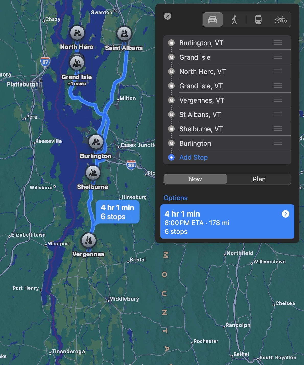 Here's its 6-day plan:
- Burlington to an island, spend the night.
- Go north, do a loop, come back to where you started.
- Go back to Burlington then south to Vergennes.
- North through Burlington to St. Albans.
- South through Burlington to Shelburne.
- Back to Burlington.
That's a lot of time in Burlington!
It did try to find hotels and recommend some restaurants, which is nice, but I'm not sure how many of them are even real (I gave up looking after the first one was fake), and I don't much care since the plan itself is terrible. But there's a world of LLMs to try, right? They all make mistakes, but maybe they make different mistakes!
Copilot confidently gave me a bunch of routes that all are supposed to be 60-70 miles... or so it says. The first leg is 37, second 23, third is a nice 74 miles, fourth is 33, fifth is 36, sixth is 34. You don't cover much of the lake, and you only get one long ride. Oh, and lunch on day 6 is at the destination.
Gemini also promises the 60-70 mile days I asked for, but...
| Day | Claimed Distance (miles) | Actual Distance (miles) |
|---|---|---|
| 1 | 65 | 27 |
| 2 | 70 | 58 |
| 3 | 40 | 16 |
| 4 | 65 | 40 |
| 5 | 50 | 28 |
| 6 | 15 | 10 |
| Total | 315 | 179 |
Not great, Google!
I had big hopes for Claude, because it sounds European so I hoped it might be into randonneuring? But it also lies about distances, gives me some weird loops that make for a lot of doubling back, calls things border towns that aren’t particularly close to the border, and seems to think everything has a lake view, even inland.
Perplexity! The name sounds confusing, but with the same easy prompt, it made an actual loop around the whole lake! Finally! It even takes you into Canada and reminds you to pack your passport!. But its plan spends the penultimate day on a 90 mile trek through and past Burlington so you can come back 35 miles the final day.
So what am I doing instead?
First, I found a route for the Champlain Bikeway on RideWithGPS, saved a copy and pruned that to only the parts I wanted to ride. From there I selected segments of that route and examined the distance and amount of climbing between towns. I adjusted the stopping places to spread hilly stretches across multiple days, and did my best to keep the distance close to our goal. On shorter days I returned to the brochures and found loops that we could check out if we wanted to add some mileage, and see more scenery.
Once I had a plan for where to stop and start each day, I saved those segments as individual routes, built a collection of routes in RideWithGPS, and organized them. I then made a checklist of places we needed to identify a place to stay and the nights we would be staying so we can find hotels. Next I'll start looking for lunch spots at the midway point of each segment and make a plan to bring food if there's nothing convenient.
It’s not perfect, and maybe I’ll find problems once we’re underway, but at least I know that I can trust the plans I’ve made to feature actual hotels and restaurants and to be span distances I think they should. Say what you will about my intelligence, but one thing I have over LLMs is that I can do basic math.
If you're thinking that you can write a better prompt and get a better answer, you may be right! But if you try it, please take the time to check how the routes and distances before sending it to me. All the responses I got looked good, and every single one of them was bad.
(This post began as a thread on Bluesky.)